Posted on May 30 2017
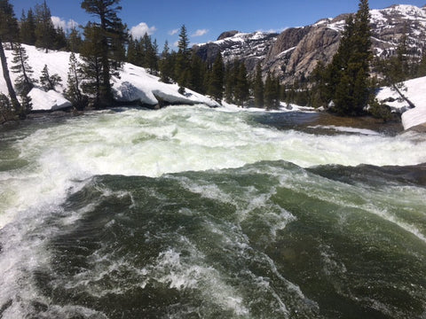
Photo by Terry (Yukon Jack) 5/26/2017
It’s time again for an updated trail report. So much is changing in the Sierra right now. Here’s the scoop from south to north.
1. Hiking to Horseshoe Meadows Road is "easy" according to hikers coming into Lone Pine today. If coming over Mulkey Pass there are 2 creek crossing. They are both passable; no water over ankle deep. Trail Pass doesn’t have big creek crossings on the way down. There’s a strong boot path you can follow. Horseshoe Meadows Road still has a gate locked ~1 mile from the parking area. Day hikers are in the area on weekends. According to your fellow hikers, ice axe, crampons, and/or microspikes are NOT required in this section. There is still snow but it's not treacherous.
2. Woods Creek Bridge (PCT Mile 800) is not out. Woods Creek is not stock passable but that doesn't affect most of you. The SEKI’s update is here.
3. Creeks are rising FAST! Really really fast! PCT hiker Marcus reported crossing creeks so deep he could not touch the bottom on his trek from Kearsarge Pass to Mammoth Lakes. The group who blazed the trail across Forester Pass sent me a report about their attempt to southbound from Tuolumne. “The (Tuolumne) river is raging and had flooded, which meant you had to ford very fast water to even get onto the bridge. If you slipped or couldn’t buck the current you would be swept over waterfalls.” After sleeping on it, the team decided to retreat; they reported the river had risen even more by the next morning.
4. Many hikers are bypassing the Sierra and heading north. Donner Pass still has a LOT of snow. Pineapple Paul snowshoed up to Sierra City.
5. Sierra City isn’t buried in snow but just above town where the PCT goes, it is! A group has gotten through from here but reported raging creeks there as well. A solo hiker turned back realizing that without a second GPS device (other than her phone) the potential to get lost/stranded if something happened to her phone was too great.
6. Pineapple Paul and a few others who hiked through this area are off the PCT walking more dirt roads and lake trails at lower elevation heading towards Quincy.
7. Old Station is easy walking right now.
8. Shortly after Burney Falls State Park there’s ~2 days of snow travel in the Shasta Trinity Forest. Chaz and Brenna reported “Grizzly Peak was sketchy and exhausting to say the least.” But the trail is snow-free the last 35-ish miles into Castella.
Additional Notes:
~The Ranger Station in Lone Pine and several of the hikers I’ve spoken with here are still recommending crampons because they have longer spikes allowing for more grip.
~The fast rising creeks means a lot of danger is ahead! Please, please exercise extreme caution in the mountains. Go with a buddy!
~Castella is as far north as I have intel right now. I’d love for you all to send me updates (mary@2footadventures.com) so I can pass them along to other hikers as you move up the trail and conditions change.
0 comments